Rendering showing the proposed “Dutch Kills Loop” (Perkins+Will/NCA/Riverkeeper)
March 21, 2018 By Nathaly Pesantez
A revitalization plan created for Newtown Creek by environmental groups and an architecture firm envisions opening up the Dutch Kills tributary in Long Island City to the public and outfitting the area with green space, a boat launch, and a walkway in a looping park.
In their 158-page “Newtown Creek Vision Plan”, compiled by Riverkeeper, the Newtown Creek Alliance (NCA), and architecture firm Perkins+Will, the groups outline 85 projects and ideas for seven sections along the entirety of the 11-mile waterway, stretching from Long Island City and Greenpoint to the furthest points of the Creek in Maspeth.
The projects all focus on goals like contamination cleanup along the heavily polluted Creek, opening the shoreline to the public with walkways and parks, and promoting green industrial uses in the stretch.
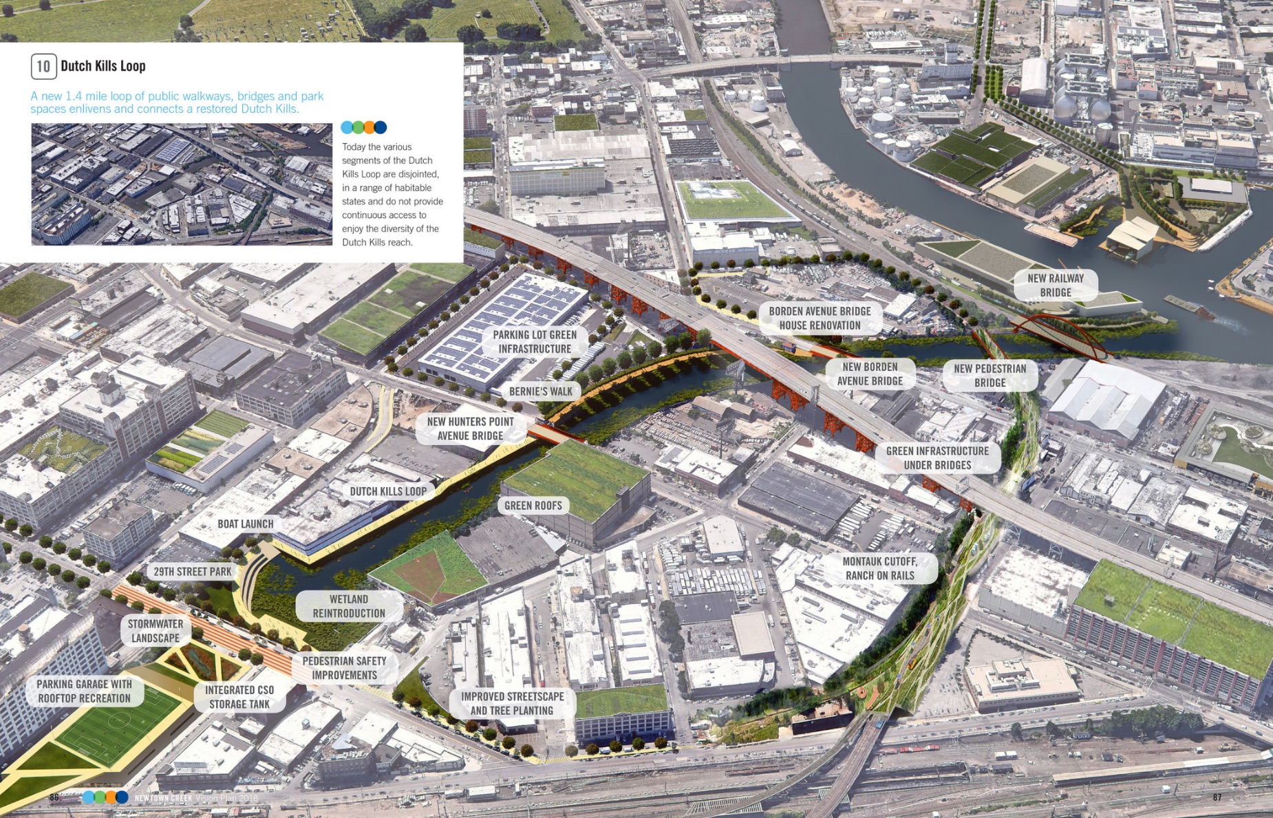
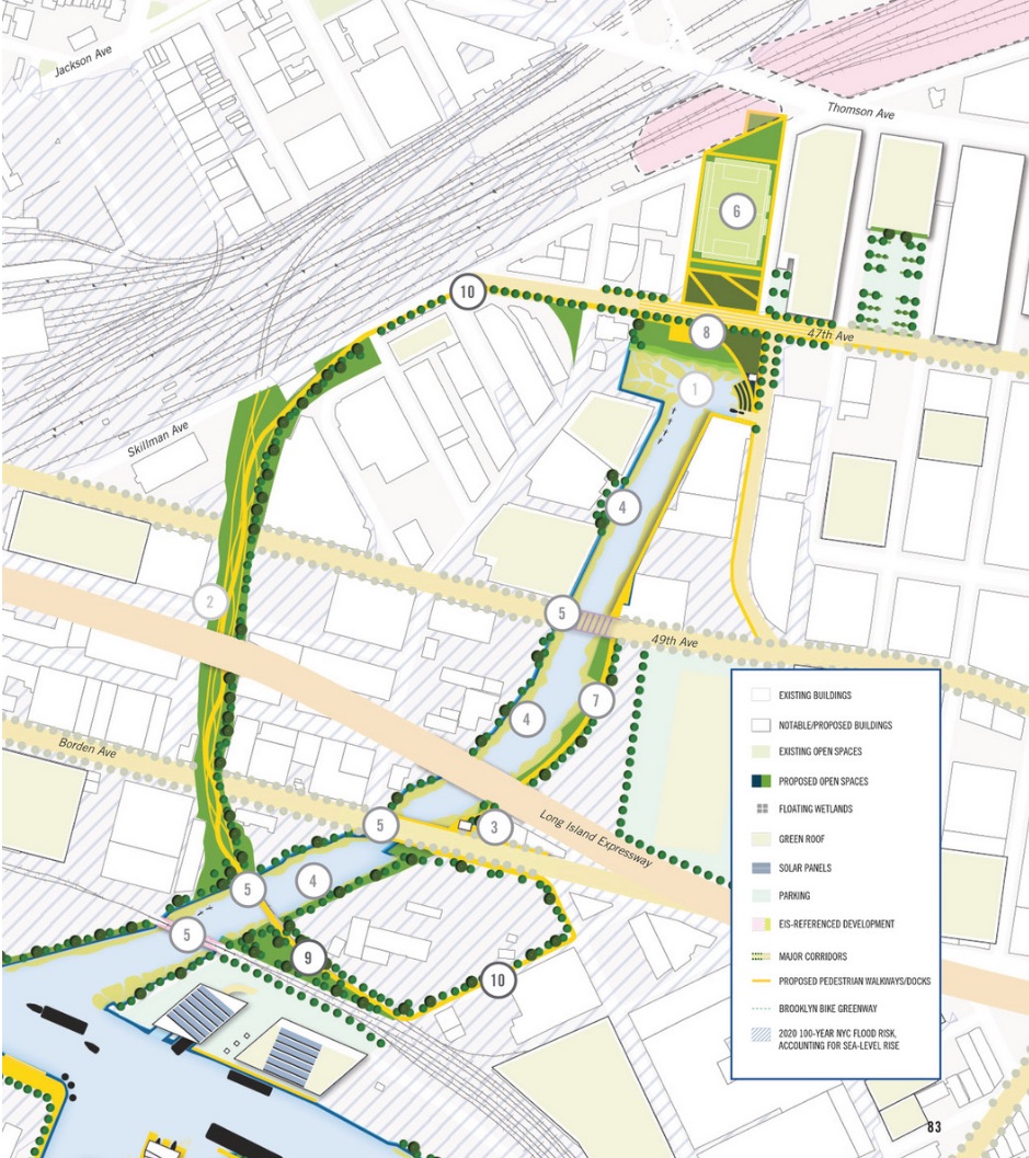
In a section focusing exclusively on the Dutch Kills tributary, the section of the Creek extending up to 47th Avenue between 27th and 29th Streets, the vision plan imagines an “environmental and recreational oasis” for the community. Several projects along the waterway tie together to make the “Dutch Kills Loop”, a proposed 1.4-mile public park and walkway.
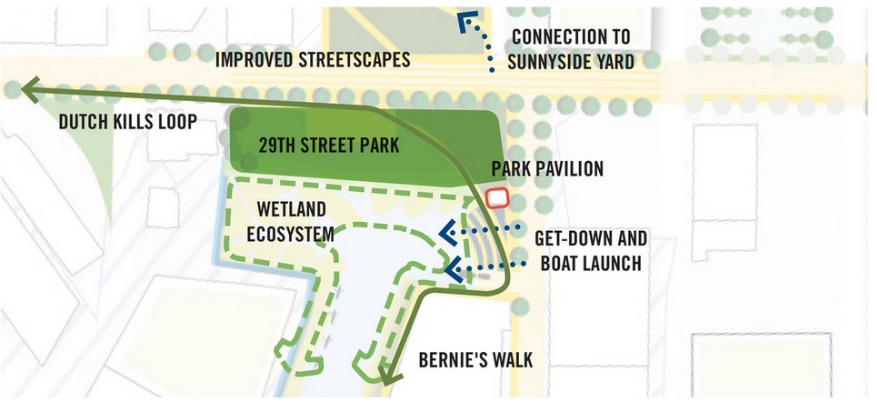
The proposed 29th Street Park at the head-end of the Dutch Kills tributary (Perkins+Wills/NCA/Riverkeeper)
There would be a park at the head-end of the tributary on 29th Street, which would grant the public access to the Creek while providing “much needed” green space to the area. Also at the head-end would be a park pavilion, a boat launch, and a restored wetland ecosystem.
North of the park, the groups call for improved streetscapes and rearranged street configurations to truly make the proposed green space accessible.
The proposed Loop would connect the 29th Street Park with “Bernie’s Walk”, another project that sees a shoreline walkway on the eastern bank of the tributary extending down toward Borden Avenue. The path would meet the already existing Bernie’s Walk further south, which is separated from truck operation facilities there by a fence. The path is named after Bernie Ente, the late historian for Newtown Creek Alliance.
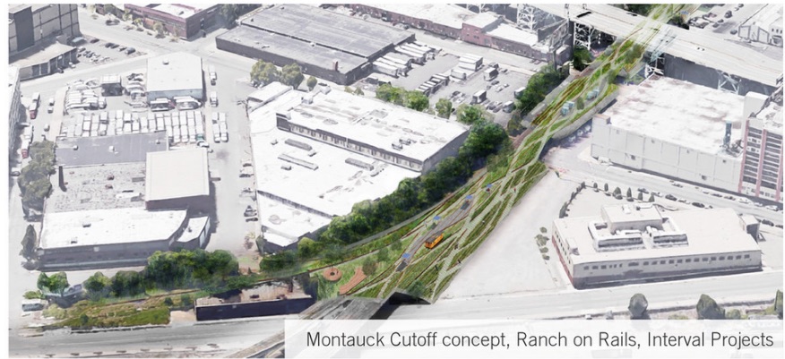
A rendering showing the Montauk Cutoff Extension in use as a public elevated park (Perkins+Will/NCA/Riverkeeper)
A proposal west of the 29th Street park calls for turning the decommissioned Montauk Cutoff rail line into an elevated park across Dutch Kills. The pedestrian walkway would be planted with native vegetation, which could also help with stormwater control, according to the group.
The resulting public park and walkway would circle 47th Avenue, go down the shoreline, and loop back around via the Montauk Cutoff and a new pedestrian bridge.
“In an area void of large public parks, the Loop provides significant benefit—physically connecting workers, students, and nearby residents with new open spaces and their local waters,” reads part of the Vision Plan.
Another major project west of the tributary calls for the southernmost portion of Vernon Boulevard to be redesigned into a public park with a plaza and boat launch. The end design is similar to the Manhattan Avenue Street End Park in Brooklyn, which was once a dumping ground.
The vision plan includes a range of other ideas for open space and restoring the Newtown Creek shoreline, as well as ideas to green the industrial facilities along the waterway.
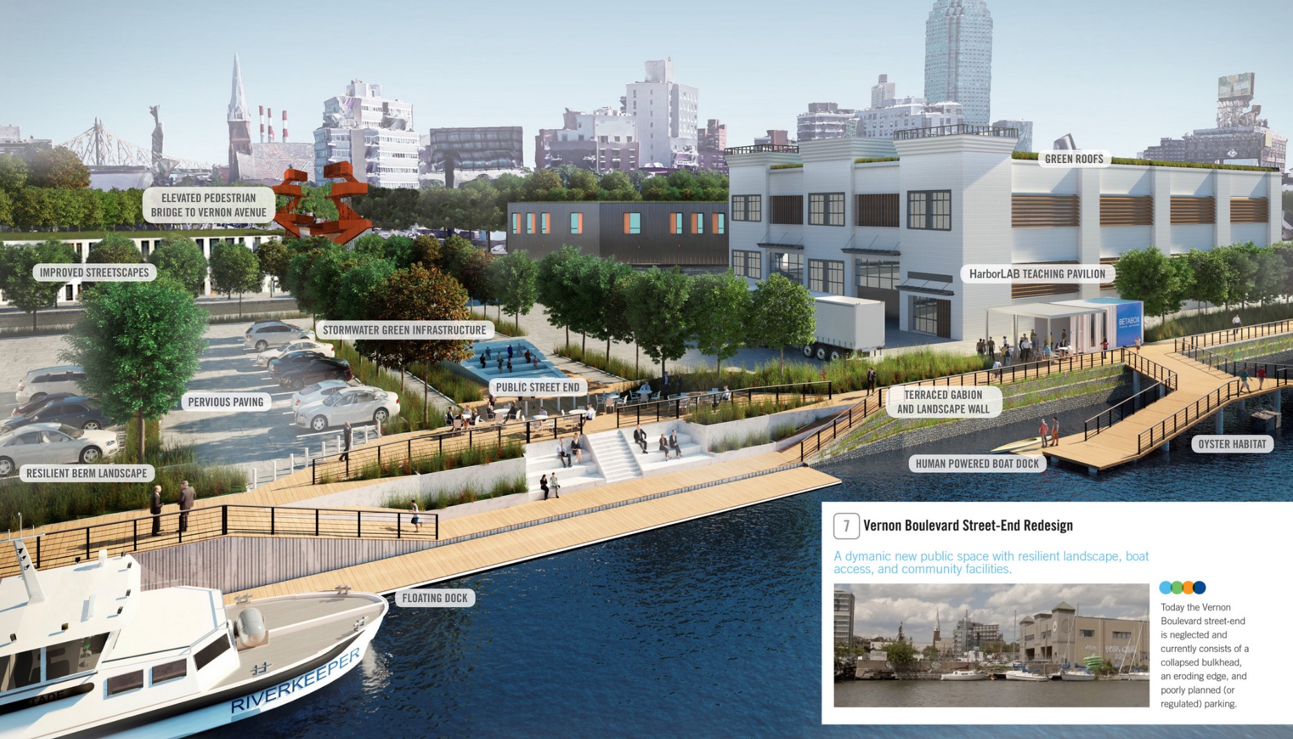
Vernon Boulevard Street-End Re-design (Perkins+Wills/NCA/Riverkeeper)
The groups say their Vision Plan is meant to serve as a guide for city agencies and the communities surrounding the Creek, who will likely have the most say in shaping the area in years to come.
A plan showing the proposed “Dutch Kills Loop” (Perkins+Will/NCA/Riverkeeper)
“Our focus was to outline transformative paths for Newtown Creek; ways to generate greater habitat, community access and sustainable use for decades to come,” said Willis Elkins, program manager at the Newtown Creek Alliance. “We hope the plan is an inspiration to local communities and to other urban waterways.”
The plan was the result of 50 meetings and workshops with the community, dating back to an initial Newtown Creek Superfund Community Advisory Group meeting in 2015, which developed the guiding principles for the report.
“We really got to know the people who live, work and spend time in these communities, and we learned a lot about what makes the waterways so valuable to them,” said Daniel Windsor, senior urban designer with Perkins+Will. “Their active involvement and enthusiasm for the project were key, and really drove the entire process.”
Newtown Creek is considered one of the most polluted industrial sites in the U.S., and was designated a Superfund site to be cleaned up by the federal government in 2010. A number of groups are currently working to figure out a remediation plan to be executed for the entire creek, which should pan out in several years’ time.
“These plans will help assure that the billions being spent on remediation… will be coupled with robust new commitments to habitat restoration, climate resilience and public recreation, as well,” said Paul Gallay, Riverkeeper president. “Through our efforts, we hope to unify the diverse communities who live and work in these areas, and maintain healthier waterways and cleaner shorelines for generations to come.”
For the full report, visit the Newtown Creek Vision Plan page.

7 Comments
The FAKE MRLIC wrote the March 23, 2018 comment.
This is going to be an amazing source of dog poo.
When are they going to make a foot bridge to Greenpoint and free the people of the Pulaski?
I’ll fix the headline for you:
“Newtown Creek MULTI BILLION DOLLAR Revitalization Plan Would Bring Looping Public Park and Walkway to Dutch Kills Tributary”
Glad that this study was paid for with donated funds to the environmental groups and architecture firm rather than with public dollars.
Even if it were a good idea it looks like it would require the city or state to buy up hundreds of millions of dollars of real estate and fight with the current owners for a decade or two to even begin thinking about this.
Where is the timeline and cost of this project? I would like a clean waterway as would everyone else. Instead of a HIGH LINED type walkway, why not put the Montauk Cutoff back in service? We could use all the transportation we can get.
Indeed – the Montauk Cutoff could be built into a new surface line to improve public transportation into Maspeth, Fresh Pond, and Middle Village. Of course, it would be great to link this kind of line into a new East River crossing to 23rd or 34th street or Phase 3 of the Second Avenue Subway, but that will never happen.
Looks like a great spot for another 2–3 homeless shelters.