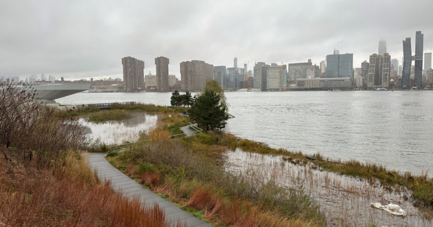
A virtual town hall will be held next week seeking community input on a proposal to build storm mitigation features along the Long Island City waterfront and at Newtown Creek. Flood water at Hunters Point South Park on Dec. 23, 2022 (Photo by Michael Dorgan)
Feb. 17, 2023 By Michael Dorgan
A virtual town hall will be held next week seeking community input on a proposal to build storm mitigation features along the Long Island City waterfront and at Newtown Creek.
The meeting, which is being hosted by the US Army Corps of Engineers (USACE) and Congresswoman Nydia Velazquez, will take place via Zoom on Feb. 23 from 7 p.m. to 9 p.m.
The proposal would see a series of flood barrier walls, levees, sea walls and an elevated promenade being constructed along the waterfront by Hunters Point South Park and Gantry Plaza State Park. The changes would start at 43rd Avenue and run south as far as Greenpoint Avenue in Brooklyn.
The project also calls for one large in-water barrier and gate — known as a storm surge gate — near the mouth of Newtown Creek. The structure would reduce the existing 400-foot wide opening to around 130 feet.
The proposal is part of a wider plan to protect the New York-New Jersey Harbor from coastal storm risks — and reduce the economic costs associated with flood and storm events. USACE released a draft plan in October identifying future flood risk areas throughout the harbor and put forward potential mitigation features.
The proposal is still in its early stages and the public is being asked to submit feedback in order to help guide USACE’s planning process.
Flood water at Hunters Point South. Video taken on Dec. 23, 2022, by Michael Dorgan
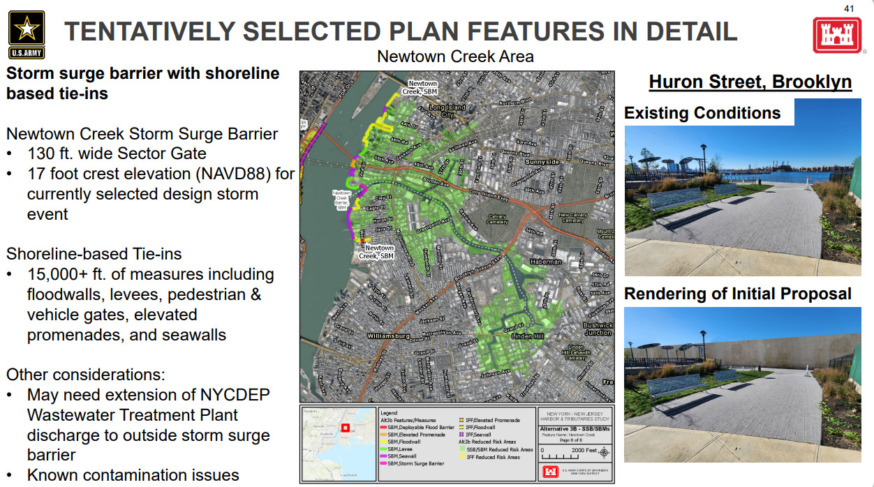
Draft plan for Long Island City waterfront and at Newtown Creek (Screenshot from USACE proposal)
The Hunters Points Park Conservancy, a local volunteer group that helps with the upkeep of the waterfront, says it has a number of concerns about the proposal. Representatives from the group will be attending the meeting.
For instance, the HPPC says it fears that the restored wetlands at Hunter’s Point South Park may be destroyed to make way for the structures.
It also says the project does not properly address long-term sea level rise threats, and instead focuses mostly on storm surge events.
The Newtown Creek Alliance, a local nonprofit group that aims to revitalize the creek, has also said that the project does not tackle sea level rises, particularly around Newtown Creek.
The Newtown Creek Alliance also has misgivings about the proposed storm surge gate, which the group says will fundamentally change the flow of water to and from the creek.
“We need to better understand how this permanent restriction to water flow would impact the creek’s water quality, sediment deposition, fish and marine wildlife passage, Superfund remedies, as well as maritime and recreational use near the mouth,” the group said in a critique of the proposal.
Join me and other government officials for a town hall about US Army Corps plans to build a more resilient North Brooklyn waterfront on Thursday, February 23 from 7:00-9:00PM.
This event will also be virtual, more information below ⬇️ pic.twitter.com/tSGDzhH5Kt
— Rep. Nydia Velazquez (@NydiaVelazquez) February 15, 2023
Hunters Point South Park on Nov. 2, 2022 (Photo by Michael Dorgan)

One Comment
Have you seen the illustrations of the 20 foot high flood walls & gates proposed along the Greenpoint waterfront and elsewhere? (See below)
NOW is the time for both Greenpoint residents and their elected officials to comment on these proposeals – and on any proposed changes or improvements. In Brooklyn, a floodwall would run along the East River from Kent Street to connect with a storm surge gate straddling Newtown Creek. How will the flood walls impact our India Street ferry service pier that extends so far out? Can these walls be widened so as to at least allow use of their tops as seaside walkways? Or will we be simply walled off from the waterfront? Will the areas of Greenpoint south of the flood wall be at greater risk of having storm flood water diverted there, causing unintended consequences & flooding? How will the barriers at the mouth of Newtown Creek impact the cleanup & health of the creek, which currently is partially flushed out by the East River tides? Can the gates or walls at the mouth of Newtown Creek perhaps include a minimal pedestrian/bike bridge along the top to Long Island City, allowing easy access between it and Greenpoint? Are there alternatives? Are there better solutions? I have heard very little mention of these very costly & crucial proposeals, proposals that will greatly impact and alter our neighborhood (and our relationship to the wayerfront) –and that lack of concern troubles me. Does it trouble you as well?
https://www.6sqft.com/army-corps-of-engineers-releases-first-renderings-of-nyc-sea-walls-for-coastal-storm-protection-plan/?utm_source=6sqft+Weekly+List&utm_campaign=b07ca084b7-EMAIL_CAMPAIGN_2017_05_26_COPY_01&utm_medium=email&utm_term=0_24f851d35f-b07ca084b7-262526657