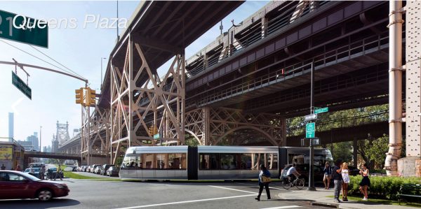
Rendering of the BQX at Queens Plaza (NYC EDC)
Aug. 30, 2018 By Nathaly Pesantez
The city has unveiled an updated plan for its controversial Brooklyn Queens Connector, the street car system planned to run along a number of waterfront neighborhoods of the two boroughs.
The revised route, outlined in the Economic Development Corporation’s conceptual design report, reduces the length of the route by five miles and notably eliminates Sunset Park. The route now goes from Astoria to Red Hook and is 11 miles.
The updated plan also nails down the streetcar’s pathway, and proposes a new bridge between Queens and Brooklyn for the system to run through.
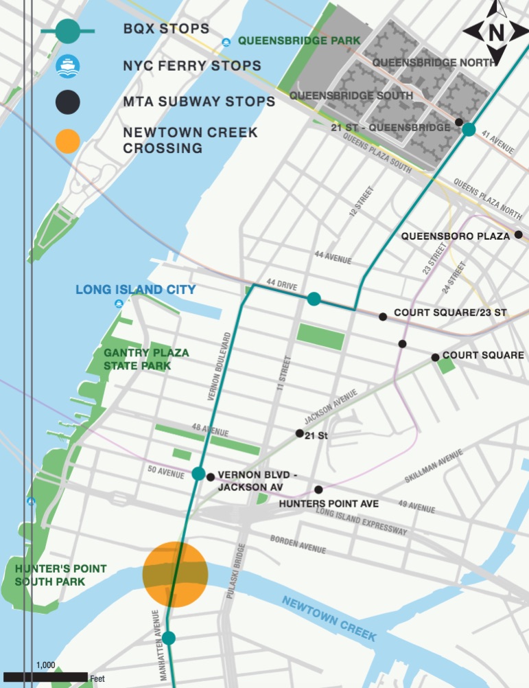
The bridge, with an approximate span of 1,700 feet, would go over Newtown Creek and connect Vernon Boulevard in Long Island City to Greenpoint’s Manhattan Avenue.
The bridge would include a drawbridge span, and will also accommodate cyclists and pedestrians.

Proposed BQX stops in Long Island City, including the location of a new bridge. (NYC EDC)
On the Long Island City side, the BQX would run through parts of the LIRR rail yard before reaching the crossing point into Brooklyn.
The city does not have to acquire private property for the bridge to go through.
“Both approaches to the creek are on public right-of-way so no property acquisitions are expected for this bridge,” part of the report reads.
The city’s last BQX report was issued in 2016, where it outlined a series of proposed routes and pros and cons for each. The streetcar, for example, was mainly geared for a pathway down 11th Street and over the Pulaski Bridge in Long Island City.
Now, after running through the new bridge, the streetcar would go on Vernon Boulevard all the way to 44th Drive, where it would turn on 21st Street and continue north all the way to a terminus at Astoria Boulevard. A total of six stops are proposed between the terminus and Long Island City before crossing into Brooklyn.
The city says the route here is situated to support the expected growth on the waterfront and the commercial corridor. In addition, the pathway will be designed to be resilient against flooding, allowing service to be quickly restored in case of flooding.
The project is now estimated to cost $2.73 billion, up from the $2.5 million given two years ago. In addition, the city is expecting construction to begin in 2024, rather than 2019, and end in 2029.

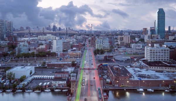
The BQX running through the Pulaski Bridge in a prior idea. (NYC EDC)
Furthermore, the city will seek federal funding for the project, a departure from its initial plan to have the streetcar fund itself through value capture, or the money collected from increased property values along the route.
The fare is still expected to be pegged to the bus and subway, with the streetcar running every 5 minutes in peak hours and extending to every 20 minutes during late night hours. Service during overnight hours, however, is still being worked out.
The EDC’s new report comes as the city wrapped up its delayed two-year feasibility study for the project. The project’s feasibility has been a subject of much scrutiny since last year, after a leaked internal memo indicated the streetcar’s financial viability was in doubt.
“The Brooklyn-Queens waterfront has experienced incredible growth. Now it’s time for our transit system to catch up,” said Mayor Bill de Blasio in a statement today. “The BQX is one of the biggest, most ambitious projects in a generation. It will be a challenge, but New York City is taking it on.”
With the green-lighted BQX project, the city said the environmental impact study process will begin this winter, with the public review process known as ULURP to kick off in 2020.
For the full report, click here.
25 Comments

Will NEVER happen. Don’t kid yourselves.
Oh dear where will the cops park their own cars?
Yet another boondoggle idea from the mayor. And not until the 12th paragraph is there a mention of the wildly over-the-top cost which ballooned from $2.5 MILLION to $2.73 BILLION!
Does debacle ring a bell….Vernon blvd. is so congested as it is! Did any of these people coming up with this plan walk on Vernon blvd during the morning rush hour or during the day. Did they consider parking, building shuttles, regular buses and school buses and oh yes bike paths? Come on guys what are we doing here?
It’s not just Vernon that’s a mess — it’s the bottlenecks at the Vernon-Jackson-51st Ave and Vernon-Borden intersections, where the trolley will have to traverse. The only way the trolley could ever feasibly work is if traffic can be rerouted to the LIE and tunnel entrance without using those crammed areas.
This is alarming. If “new and improved ” versions are being presented, some powers that be seem determined to foist this upon the city. Federal money will pay for it? Good luck..
Why doesn’t the report show the proposed street conditions with the BQX in Long Island City? All other neighborhoods are shown. Is it because it’s actually impossible to run the trolley on Vernon?
Where are residents going park their cars. ????
Vernon Blvd. is already a disaster. The businesses have a tough time getting 0deliveries and loading their trucks. Where on Astoria Blvd. will the terminus be built? 2.7 billion is the estimate by the time its built it was I’ll be over 3 billion,for 11 miles. That makes a lot of sense.
Other then being newer and cooler what does a trolley do that a bus can’t? If anything the trolley is less versatile as it’s a slave to the tracks it runs on and cannot be rerouted if need be (street fair, hazards, construction). Just paint the route blue and run a new bus line, it will be much cheaper with the same results.
This is my favorite part of the project. There used to be a bridge there, glad it’s finally being replaced.
Isnt Vernon blvd too congested as is? Where is the street car going to go?
Hopefully they’ll take the new mass transit instead.
Except it doesn’t really add any new stops. The only stop on Vernon is next to the 7. The other 2 are next to the E and the F. It just adds congestion and everyone still has to walk to the same places they walked before to catch a train. Run it closer to the water to link the ferries, and then back up 50 ave to link to the 7 before crossing the new bridge. Double the number of stops.
Does this mean no cars on Vernon?! Or Vernon is a narrow one way street? How does that help traffic when I can see this thing being emptier than the G train? This is a project nobodybasked for. Meanwhile Mayor Dumbo can’t get a handle on crime, homelessness or the subways.
I remember an article earlier this year saying this idea would be DOA of a BQX trolley. Many people said it would just aid developers. Build a link to LaGuardia Airport . Build the long closed Rockaway LIRR line to the city .Just don’t build this garbage. Come on with the dislikes developers on LICPOST, I know they’re coming.
Same old tired theme.
Didn’t the most recent studies by the city say the BQX is unworkable no matter how much taxpayer money they pour into it?
Let this boondoggle die now.
Did any of the traffic planners actually take a walk along Vernon before coming up with this plan? Unless commercial truck traffic is banned to alleviate the chronic congestion in much of Hunters Point, there is no way in hell that the BQX can feasibly run on that street. Dingbats.
Maybe the $2.73 billion could instead be used to replace the electrical tape holding all of the signals together on the 7 line.
https://bridgehunter.com/ny/queens/vernon-avenue/
Oh great, how will I complain about the trains being overcrowded when DumBlasio provides us with alternative transportation?
I only respect politicians that help the working class, the way Trump did when he gave millions of dollars in tax breaks to the super rich.
Also, Hillary’s emails.
And how is this better than 10 express buses?
Dedicated center right of way and a new bridge to cross into brooklyn…?
Roads can be painted to be exclusive for buses. The bridge can be built regardless and there was a separate proposal to add a bridge here without BQX.